• SAM2 Data (September 2019)

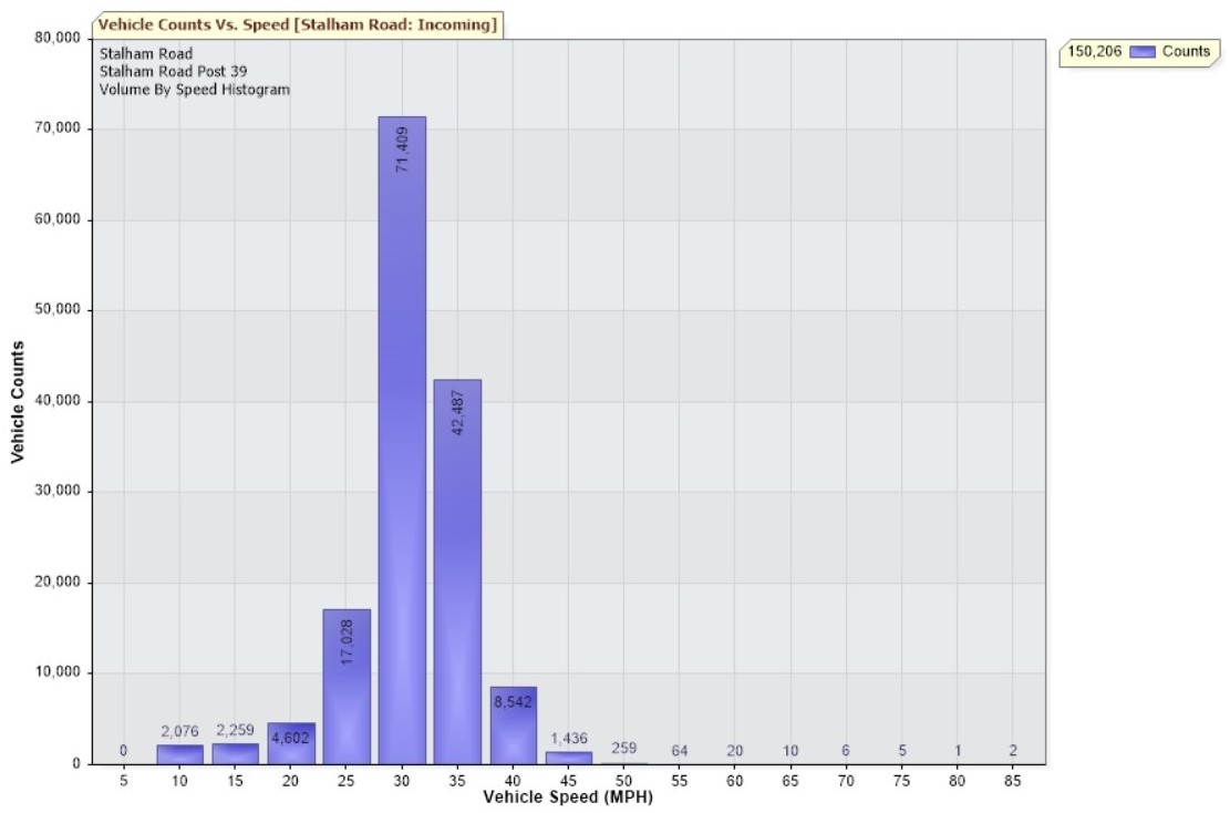
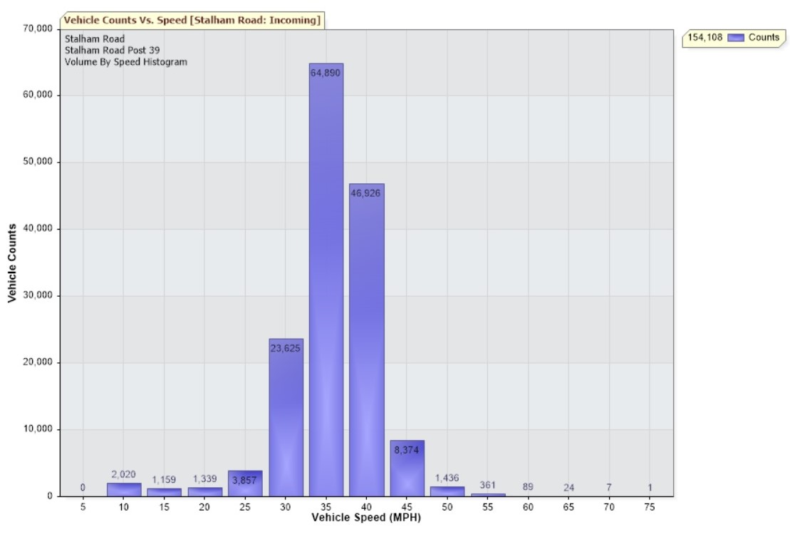
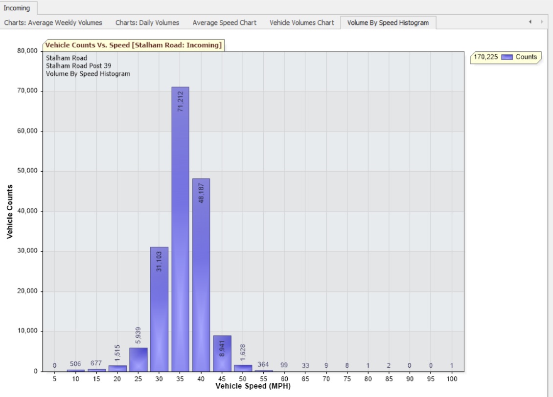
    In September 2019, the speeds of more than 150,000 vehicles were recorded by HPC’s SAM2 device on Stalham Road. The unit monitored outgoing traffic and was calibrated to 30mph, as per the official speed limit for this stretch of road. Despite the 30mph speed limit, however, more than 52,000 vehicles were recorded at speeds of 35mph or more, with 367 of these vehicles travelling at speeds of 50mph or more. The data collected by the SAM2 has been shared with Norfolk Police. Please slow down in our village.

    SAM2 Data September 2019

  • SAM2 Data (August 2019)

    During August, our SAM2 sign was again placed on Stalham Road, but this time tracking traffic leaving the village.

    SAM2 Data August 2019

    The speed limit on this section of road is 40mph. Of the 154,000 vehicles that passed the sign, less than 7% were recorded at 45mph or more. 120 vehicles were recorded at 60mph or more. As always, Hoveton Parish Council has passed this data to our local police.

  • SAM2 Data (July 2019)

    Interesting results from the much-discussed deployment of Hoveton Parish Council’s SAM2 sign on Stalham Road in July. Over a four-week period, more than 170,000 vehicles were detected. The speed limit on this stretch of road is 40mph. Only 6% of vehicles were recorded at speeds of 45mph or more. There were over 150 vehicles recorded at 60mph or more, and one at a truly eye-watering 100mph. As always, Hoveton Parish Council has passed this data to our local police.

    SAM2 Data July 2019

    During this deployment the sign was set to trigger a warning at 30mph. When it is next placed in this location, the sign will be calibrated to trigger at 40mph so we can compare the results and judge what effect, if any, the sign is having on traffic speeds.

  • New SAM2 Location

    In response to suggestions from residents, Hoveton Parish Council has now placed its SAM2 sign on Stalham Road, just before the start of the formal 30mph zone. We hope this will encourage drivers to slow down as they enter the village, and well before the approach to the Brook Park roundabout. As always, we will publish the data when it is available. We work for you.

  • SAM2 Data (May 2019)

    The image below shows the latest data from Hoveton Parish Council’s speed monitoring equipment on Tunstead Road. This data captures traffic coming into the village between 29th April and 2nd June 2019, just a few hundred yards from Broadland High Ormiston Academy. Well over 40% of the traffic recorded here was travelling at speeds of 35mph or more; more than 500 vehicles (around 12 a day) were recorded at 50mph or more; and 35 individuals judged it acceptable to drive at speeds of 60mph or more, right outside our high school. As always, Hoveton Parish Council has passed this data to our local police.

    SAM2 Data May 2019

    Our speed monitoring equipment (SAM2) will soon be used on Stalham Road, so data may be gathered and provided as evidence of need for speed enforcement on Stalham Road, as has been done successfully on Tunstead Road. Two volunteers will kindly be looking after the SAM2 on Stalham Road and Tunstead Road, but sadly Hoveton Parish Council doesn’t have the human resources necessary to rotate the sign to other suggested locations at the moment (Horning Road, Horning Road West and Station Road). Local residents who wish to see the SAM2 used elsewhere are therefore asked to consider volunteering their help to make this possible. Please contact Cllr Alex Howe ([email protected] or on 01603 783 096) to find out more about what’s involved.

Cookies For Comments Image